

 with Famous Bucas Grande Tour!")


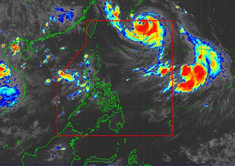

Typhoon Falcon maintained its strength as it moved toward the sea southeast of Okinawa islands on Tuesday morning, PAGASA reported.
The center of the eye of the typhoon was estimated at 925 kilometers east northeast of Extreme Northern Luzon moving northwestward at 20 km/h packing maximum sustained winds of 175 km/h near the center and gustiness of up to 215 km/h.

In its 5 a.m. bulletin, the weather bureau reported that the southwest monsoon or habagat enhanced by Typhoon Falcon will bring occasional to monsoon rains over the western portion of Luzon in the next three days.
“Forecast rainfall are generally higher in elevated or mountainous areas. Under these conditions, flooding and rain-induced landslides remains highly likely especially in areas that are highly or very highly susceptible to these hazard as identified in hazard maps and in localities that experienced considerable amounts of rainfall for the past several days,” PAGASA said.

There are no wind signals raised in any area in the country.
Zambales and Bataan will have monsoon rains due to the southwest monsoon with the possibility of flooding or landslides due to scattered to widespread heavy rains.
Metro Manila, Pangasinan, Pampanga, Bulacan, and Occidental Mindoro will have occasional rains also due to the southwest monsoon with possible flooding or landslides occurring due to moderate to heavy rains.
Cordillera Administrative Region, Cagayan Valley, Calabarzon, the rest of Ilocos Region, the rest of Central Luzon, the rest of MIMAROPA, and Antique will have cloudy skies with scattered rain showers and thunderstorms due to the southwest monsoon. Flash floods or landslides may occur in these areas due to moderate to at times heavy rains.
The rest of the country will have partly cloudy to cloudy skies with isolated rain showers or thunderstorms due to the southwest monsoon and localized thunderstorms. Flash floods or landslides may occur during severe thunderstorms.
Severe winds
“Due to the very expansive wind field of the typhoon, the hoisting of Wind Signal due to Falcon over Batanes is no longer ruled out,” the weather bureau reported.
The enhanced southwest monsoon will bring also gusty conditions over the following areas, especially in coastal and upland/mountainous areas exposed to winds in Batanes, Babuyan Islands, Abra, Benguet, Zambales, Bataan, the central and southern portions of Aurora, Pampanga, Bulacan, Metro Manila, and most of Ilocos Region, Calabarzon, Mimaropa, Bicol Region, and Western Visayas.
Hazards affecting coastal waters
The southwest monsoon enhanced by Falcon will bring moderate to rough seas over the coastal waters along the northern (1.25 to 2.5 m), western (1.5 to 3.0 m) and southern (1.5 to 2.5 m) seaboards of Luzon. Mariners are advised to take precautionary measures.
Track and intensity outlook
The typhoon is forecast to turn west northwestward and begin decelerating as it approaches the waters southeast of Okinawa Islands and may exit the Philippine Area of Responsibility (PAR) by Tuesday afternoon or evening. —BAP/KG, GMA Integrated News
7 Easy Ways To Make Extra Money At Home
Learn Trading and know Two Platform that easy to Start With


