

 with Famous Bucas Grande Tour!")


Tropical Cyclone Wind Signal (TCWS) No. 1 was raised over nine areas in Luzon on Monday as Super Typhoon Goring became a typhoon while looping over the Philippine Sea, PAGASA said in its weather forecast.
Areas under TCWS No. 1 are:
- Batanes;
- Babuyan Islands;
- the northern and eastern portions of mainland Cagayan (Camalaniugan, Pamplona, Gonzaga, Santa Teresita, Baggao, Buguey, Santa Ana, Claveria, Aparri, Ballesteros, Abulug, Sanchez-Mira, Santa Praxedes, Allacapan, Lal-Lo, Lasam, Peñablanca, Iguig, Amulung, Gattaran, Alcala);
- the eastern portion of Isabela (Dinapigue, San Mariano, San Guillermo, Ilagan City, Tumauini, San Pablo, Cabagan, Maconacon, Divilacan, Palanan);
- the northern and central portions of Aurora (Casiguran, Dinalungan, Dilasag, Baler, Dipaculao, Maria Aurora, San Luis);
- Polillo Islands;
- the northern and eastern portions of Camarines Norte (Capalonga, Jose Panganiban, Paracale, Vinzons, Talisay, Daet, Mercedes) including Calaguas Islands;
- the northeastern portion of Camarines Sur (Siruma, Tinambac, Lagonoy, Garchitorena, Caramoan); and
- the northern portion of Catanduanes (Panganiban, Caramoran, Viga, Bagamanoc, Pandan).

The above-mentioned areas will have strong winds in 36 hours with speeds of 39 to 61 km/h, posing minimal to minor threat to life and property.

PAGASA said Extreme Northern Luzon and the northern or northeastern portion of mainland Cagayan may be placed under higher TCWS later on Monday or on Tuesday.
“Hoisting of Wind Signal No. 3 or 4 over the Batanes-Babuyan Islands area is not ruled out,” the weather bureau said.
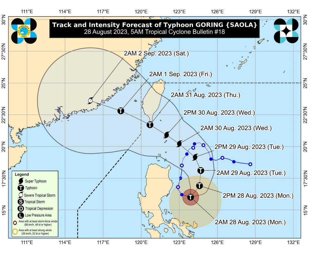
At 4 a.m., the eye of Goring was estimated to be located at 210 km east of Casiguran, Aurora.
Goring has maximum sustained winds of 175 km/h near the center, gustiness of up to 215 km/h, and central pressure of 940 hPa.
The typhoon is moving east southeastward at 15 km/h, continuing its counter-clockwise loop over the Philippine Sea.
From Goring’s center, strong to typhoon-force winds are extending outwards up to 280 km.
Rainfall
The northeastern portion of mainland Cagayan will have 50 to 100 mm of rainfall on Monday.
The rainfall forecast by PAGASA for Tuesday and Wednesday is as follows:
- Tuesday: 50-100 mm: Batanes, Babuyan Islands, and the northern portions of mainland Cagayan, Apayao, and Ilocos Norte
- Wednesday:
- Greater than 200 mm: Batanes
- 100-200 mm: Babuyan Islands
- 50-100 mm: The northern portions of mainland Cagayan, Apayao, and Ilocos Norte
“Forecast rainfall are generally higher in elevated or mountainous areas. Under these conditions, flooding and rain-induced landslides are still expected especially in areas that are highly or very highly susceptible to these hazards as identified in hazard maps and in localities that experienced considerable amounts of rainfall for the past several days,” PAGASA said.
Goring will enhance the Southwest Monsoon (Habagat) which will bring occasional or monsoon rains over the western portions of Central Luzon, Southern Luzon, and Visayas over the next three days.
The Habagat will also bring gusty conditions over the following areas not under any TCWS, especially in coastal and upland/mountainous areas exposed to winds:
• Monday: Aurora, Bataan, Metro Manila, Calabarzon, Mimaropa, Bicol Region, Visayas, Dinagat Islands, Camiguin, and most of Zamboanga Peninsula.
• Tomorrow: Aurora, Bataan, Bulacan, Metro Manila, Calabarzon, Mimaropa, Bicol Region, Visayas, Dinagat Islands, Camiguin, and most of Zamboanga Peninsula.
• Wednesday: Aurora, Bataan, Zambales, Pampanga, Bulacan, Metro Manila, Calabarzon, Mimaropa, Bicol Region, and most of Visayas.
Coastal waters
PAGASA raised a gale warning for the northern and eastern seaboards of Northern Luzon, the eastern seaboards of Central Luzon, the seaboards of Southern Luzon, and the western seaboard of Visayas.
The weather bureau said civilian maritime activities such as sea travel may be disrupted due to hazardous sea condition.
Track, intensity outlook
On Monday, Goring is expected to turn generally northeastward and northward, then generally northwestward on Tuesday toward the Bashi Channel and the vicinity of Batanes.
Between Wednesday morning and evening, Goring will make a close approach to Batanes at or near its peak intensity, and a landfall is not ruled out.
Between Wednesday evening and Thursday morning, Goring will make a close approach to the southern portion of Taiwan, then exit the Philippine Area of Responsibility on Thursday morning or afternoon.
Goring will then cross the Taiwan Strait and make landfall over southeastern China on Friday evening or on Saturday early morning.
“GORING is forecast to slightly weaken further in the next 12 hours due to upwelling of cooler ocean waters and onset of dry air intrusion before re-intensifying as it turns northwestward. It may be upgraded again to super typhoon category by mid tomorrow,” PAGASA said.
The weather bureau advised the public and disaster risk reduction and management offices concerned to take all necessary measures to protect life and property.
PAGASA will issue the next tropical cyclone bulletin at 11 a.m.
Effects
In Cagayan, More than 1,000 residents have been displaced due to the effects of Typhoon Goring, according to the report of GMA Regional TV’s Jasmin Gabriel-Galban on Unang Balita on Monday. The evacuees include members of the IP community in Gonzaga town.
Ruelie Rapsing, the head of the Cagayan Provincial Disaster Risk Reduction and Management Office (PDRRMO), said evacuees will be sent home when the weather improves.
“Kung bubuti po at siisplip ang ating araw ay pauwiin na po natin sila. Sila ay nasa pangangalaga po ng kanilang local government units na nagpapakain sa kanila,” Rapsing told Unang Balita in an interview.
(If the weather condition improves and we will see the sun, we may let them go home. They are under the care of their local government units.)
Rapsing said there have been no reports yet of casualties, injuries, or missing individuals due to Goring.
He said the PDRRMO recorded power interruption in some areas on Saturday but this has been addressed on Sunday night. —KG/KBK, GMA Integrated News
7 Easy Ways To Make Extra Money At Home
Learn Trading and know Two Platform that easy to Start With


