

 with Famous Bucas Grande Tour!")


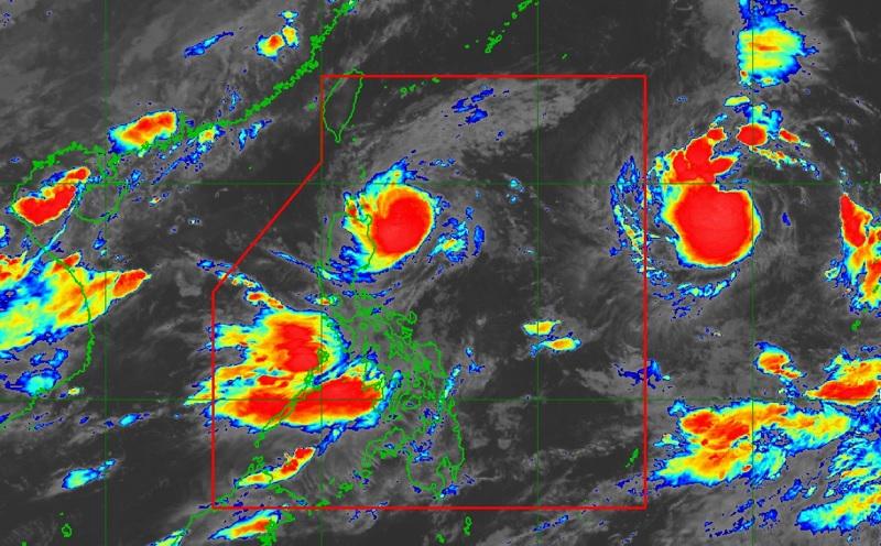

Typhoon Goring maintained its strength as it continues to approach the Luzon Strait as Signal No. 3 remains over a portion of Babuyan Islands, PAGASA reported.
In its 5 a.m. Tropical Cyclone Bulletin, PAGASA reported that the center of the eye of Typhoon Goring was estimated at 220 kilometers east of Aparri, Cagayan packing maximum sustained winds of 155 kilometers near the center, gustiness of up to 190 km/h, and central pressure of 950 hPa.

Goring continues to move north northwestward at the speed of 10 km/h with strong to typhoon-force winds extend outwards up to 280 km from the center.
Tropical Cyclone Wind Signal No. 3 is hoisted over the following areas:
- the northeastern portion of Babuyan Islands (Babuyan Is.)

TCWS No.2 is raised over the following areas:
- Batanes
- the rest of Babuyan Islands
- the extreme northeastern portion of mainland Cagayan (Santa Ana, Gonzaga)
TCWS No.1 is hoisted over the following areas:
- the northern and eastern portions of mainland Cagayan (Camalaniugan, Pamplona, Santa Teresita, Baggao, Buguey, Claveria, Aparri, Ballesteros, Abulug, Sanchez-Mira, Santa Praxedes, Allacapan, Lal-Lo, Lasam, Peñablanca, Iguig, Amulung, Gattaran, Alcala, Santo Niño)
- the eastern portion of Isabela (Dinapigue, San Mariano, Ilagan City, Tumauini, San Pablo, Cabagan, Maconacon, Divilacan, Palanan)
- the northern portion of Apayao (Flora, Calanasan, Luna, Pudtol, Santa Marcela)
- the northern portion of Ilocos Norte (Vintar, Pasuquin, Burgos, Dumalneg, Adams, Pagudpud, Bangui)
Hazards affecting land areas
Forecast accumulated rainfall of 100-200 mm over the northeastern portion of Babuyan Islands and 50-100 mm over Batanes, Babuyan Islands, Ilocos Norte, the northern portion of Abra, the northern portion of Apayao, and the northern and eastern portions of mainland Cagayan.
Flooding and rain-induced landslides are expected especially in areas that are highly or very highly susceptible, PAGASA reported.
“The enhanced southwest monsoon will also bring occasional or monsoon rains over the western portions of Central Luzon, Southern Luzon, and Visayas over the next three days,” the agency also said.
PAGASA said Batanes and Northeastern Cagayan, including Babuyan Islands, will be stormy due to Typhoon Goring. Flooding or landslides due to moderate to heavy rains may occur with minor to moderate threat to lives and properties due to strong winds.
Ilocos Norte, Apayao, rest of mainland Cagayan, and Isabela will experience rains with gusty winds also due to Goring with flooding or landslides possibly occurring due to moderate to heavy rains. There may also be minimal to minor threat to lives and properties due to strong winds.
Zambales, Bataan, Occidental Mindoro, and Northern Palawan will have monsoon rains but this would be due to the southwest monsoon with flooding or landslides occurring due to scattered to widespread rains.
For Western Visayas, the rest of Central Luzon, the rest of MIMAROPA, Cavite, and Batangas, PAGASA said there will be occasional rains due to the southwest monsoon with flooding or landslides possibly occurring due to moderate to heavy rains.
Metro Manila, Zamboanga Peninsula, the rest of Luzon, and the rest of the Visayas will have cloudy skies with scattered rain showers and thunderstorms due to the southwest monsoon with flooding or landslides possibly occurring due to moderate with at times heavy rains.
The rest of Mindanao will have partly cloudy to cloudy skies with isolated rain showers or thunderstorms due to the southwest monsoon and localized thunderstorms with flash floods or landslides possibly occurring during severe thunderstorms.
Hazards affecting coastal waters
The weather bureau reported that a gale warning is in effect for the northern and eastern seaboards of Northern Luzon, the eastern and western seaboards of Central Luzon, the seaboards of Southern Luzon, seaboards of Visayas, and the northern seaboard of Mindanao.
Track and Intensity Outlook
Goring is forecast to follow a mainly northwestward or west northwestward path across the Luzon Strait from today until it exits the Philippine Area of Responsibility (PAR) Wednesday evening or Thursday morning.
The typhoon may pass very close or make landfall in the vicinity of Batanes between Wednesday morning and afternoon (although a slight southward shift in the track forecast may bring the eye and eyewall region of the typhoon to the northern portion of Babuyan Islands).
The typhoon is forecast to re-intensify and may peak at near-super typhoon strength by the time it passes very close or over Batanes (although re-intensifying into a super typhoon is not ruled out).
“Outside the PAR region, the typhoon will continue its west northwestward movement for the remainder of Thursday before turning more westward by Friday, increasingly unfavorable conditions over the waters southeast of mainland China will trigger a weakening trend. By the time GORING makes landfall in the vicinity of southeastern China (near Hong Kong/Pearl River Delta area) on Sunday, it will have weakened to minimal typhoon strength,” PAGASA reported. — BAP/RSJ, GMA Integrated News
7 Easy Ways To Make Extra Money At Home
Learn Trading and know Two Platform that easy to Start With


