

 with Famous Bucas Grande Tour!")


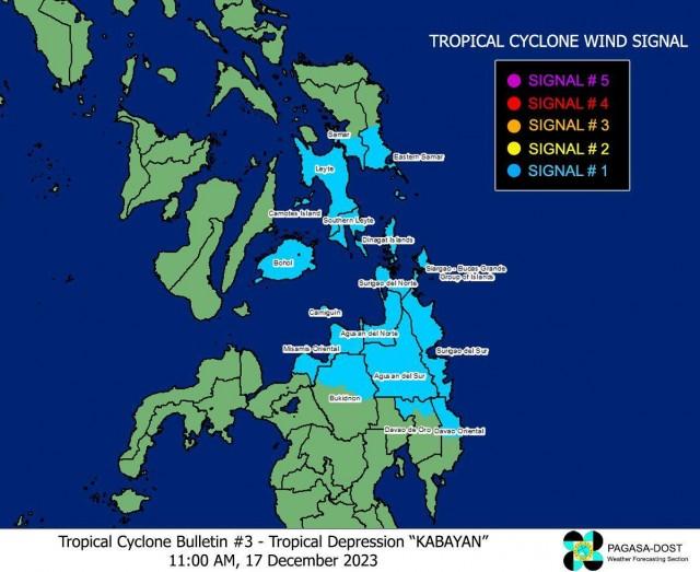
Tropical Cyclone Wind Signal (TCWS) No. 1 remained hoisted over 16 areas in Visayas and Mindanao even as Tropical Depression Kabayan decelerated while moving north northwestward near the Mindanao landmass, PAGASA said late Sunday morning.

As of 11 a.m., the state weather bureau said the following areas were under TCWS No.1:
- the southern portion of Samar (Basey, Santa Rita, Marabut, Talalora, Villareal, Pinabacdao);
- the southern portion of Eastern Samar (Maydolong, City of Borongan, Quinapondan, Guiuan, Lawaan, Balangiga, Llorente, Giporlos, Salcedo, Balangkayan, General Macarthur, Hernani, Mercedes);
- Leyte;
- Southern Leyte;
- Bohol;
- Camotes Islands;
- Dinagat Islands;
- Surigao del Norte;
- Surigao del Sur;
- Agusan del Norte;
- Agusan del Sur;
- the northern portion of Davao Oriental (Cateel, Boston, Baganga);
- the northern portion of Davao de Oro (Monkayo, Laak);
- Misamis Oriental;
- Camiguin; and
- the northern portion of Bukidnon (Impasug-Ong, Malitbog, Manolo Fortich, Sumilao, Libona, Baungon, Cabanglasan, City of Malaybalay).
These areas under TCWS No.1 may experience strong winds within the next 36 hours, with speeds ranging 39 to 61 km/h. Wind impacts may also result in minimal to minor threat to life and property.

PAGASA said the center of the eye of Kabayan was last seen 440 km east of Davao City.

It has maximum sustained winds of 55 km/h near the center, gustiness of up to 70 km/h, and central pressure of 1002 hPa.
While moving slowly north northwestward east of Mindanao, Kabayan’s winds were also extending outwards up to 350 km from the center.
Winds, coastal waters
The surge of the Northeast Monsoon or Amihan will also bring gusty conditions for the next two days over the following areas not under any wind signal, especially in coastal and upland/mountainous areas exposed to winds: Batanes, Babuyan Islands, Ilocos Norte, Ilocos Sur, Aurora, Bataan, Bulacan, Rizal, Quezon, Lubang Island, Marinduque, Cuyo Islands, Bicol Region, Visayas, the northern and eastern portion of mainland Cagayan, the eastern portions of Isabela and Nueva Ecija, and portions of Cordillera Administrative Region, Zambales, Pampanga, Cavite, Mindoro Provinces.
A gale warning is also in effect for the coastal waters along the seaboard of Northern Luzon and the eastern seaboards of Visayas and Mindanao due to the Amihan surge and Kabayan.
PAGASA thus advised mariners of small seacraft to remain in port or seek safe harbor.
Track, intensity
PAGASA said Kabayan is forecast to track generally westward or west northwestward path across the Philippine archipelago over the next two days and is likely to maintain its strength until its initial landfall over Mindanao.
The possibility of it reaching tropical storm category before its landfall is not ruled out.
Kabayan is likely to make landfall along the coast of Surigao del Sur or Davao Oriental on Sunday night or early Monday morning.
It may then cross the rugged terrain of Mindanao, and emerge over Bohol Sea or Sulu Sea on Monday morning or afternoon.
PAGASA said Kabayan may weaken over land and the possibility of it being downgraded into a low pressure area while over land or after emerging over the sea is also not ruled out.
However, a re-development may still occur over the Sulu Sea in this case.
Kabayan will move across the Sulu Sea south of Cuyo Islands for the rest of Monday and into early Tuesday morning.
It is expected to make another landfall over central or southern Palawan as a tropical depression by Tuesday morning, then emerge over the Philippine Sea by noon or early afternoon of the same day.
It may then pass near or over Kalayaan Islands in the West Philippine Sea.
Rainfall
PAGASA said heavy rainfall is expected in the following areas on Sunday:
- 100 to 200 mm: Surigao del Sur, Surigao del Norte, Dinagat Islands, and Southern Leyte
- 50 to 100 mm: Eastern Visayas, Davao Region, Northern Mindanao, and the rest of Caraga
These amounts of rainfall will also pour over these areas on Monday:
- 100 to 200 mm: Surigao del Sur, Surigao del Norte, Dinagat Islands, and Southern Leyte
- 50 to 100 mm: Eastern Visayas, Central Visayas, Northern Mindanao, and the rest of Caraga.
The shear line coinciding with the passage of Kabayan may also bring heavy rainfall over the eastern portion of Southern Luzon on Sunday and over the eastern portion of Luzon on Monday.
Under these conditions, PAGASA warned that flooding and rain-induced landslides may happen, especially in areas that are highly or very highly susceptible to these hazards as identified in hazard maps, and in localities that experienced considerable amounts of rainfall for the past several days.
The Surigao del Sur Provincial Disaster Risk Reduction and Management Office (PDRRMO) said Sunday it has raised the “blue alert” status as Kabayan continues to affect certain areas in Mindanao and Visayas. —KG, GMA Integrated News
7 Easy Ways To Make Extra Money At Home
Learn Trading and know Two Platform that easy to Start With


